
Even after summer is officially over, the waters off the coast of New England beckon kayakers well into autumn. With a few weekends left before battening down for winter, a kayak excursion might just be the best way to welcome fall.
After four years of family vacations spent looking out at Minot’s Ledge Light from the beaches of Scituate, Mass., I was determined to get a close-up look at the venerable old lighthouse that juts straight out of the sea a little more than a mile offshore. After all, I own a 17-foot canvas-and-wood framed tandem kayak bought specifically for salt-water adventures.

This summer, as in the past, we rented a house for a week with my wife’s mother, sisters and their families, on North Scituate Beach just down the road from Strawberry Point, the southern entrance to Cohasset Harbor. Across the road from the house was a public beach and behind it was the eastern edge of a tidal marsh that alternately filled and drained twice a day with the tide.
America’s most dangerous beacon
One of the main shipping lanes into Boston Harbor passes Minot’s Ledge, a submerged rock outcropping and the site of numerous shipwrecks in the 18th and first half of the 19th centuries. The first Minot Light was built in 1850 of steel, but lasted barely a year before a severe storm ripped it apart, killing two assistant keepers: Joseph Wilson and Joseph Antoine. A granite replacement was completed in 1860 and still stands guard over the active shipping lane.
Because of the shipping lane and the rocks marked by the light, the local kayaking clubs suggest kayakers visiting the light know how to read the water and maneuver around rocks that can be alternately submerged and exposed, depending on the waves and swell rolling in from the sea.
I wanted to share the thrill of digging into oncoming waves and riding them back in with my sons, but because they are not experienced paddlers, I thought I’d break them in easy. A round trip in a heavy-but-stable kayak would be a workout, so I first invited Ethan, our 14-year-old, because he would make my hardiest bow paddler.
On day one, late in the afternoon on a perfectly clear day, we pushed off the kayak into a natural trough bordered by high marsh grass 50 yards behind the house. We couldn’t spend too much time in the boat because the dinner bell would ring early that night and the marshes drain fast once the tide starts flowing out. Ending our paddle bottomed out on mud with the sun going down wasn’t part of the plan.

Messing around and warming up on flat water
Ethan and I pushed off from the grass just a little before high tide. There was no perceptible movement of water, so we decided to simply paddle into progressively wider channels as we came to them. We zigzagged left and right into ever-wider channels for about 20 minutes, paddling in almost complete silence, the grass and reeds providing a sound buffer that made it seem like we were the last people on earth.
At one point a snowy egret swept across our path 20 yards ahead of us. Presently, we started to hear children’s voices drift in from somewhere across the marsh. The next turn revealed a wider expanse of water and Bassings Beach to our west. The turn also brought more sounds from across the open water ahead of us that was Cohasset Harbor.
“Where do you think those voices are coming from?” asked Ethan. I told him I didn’t know. The voices became clearer and seemed to be very close. Approaching what appeared to be the last bit of marsh jutting out from our right, I spotted a flash of white in the grass. “Egret,” I whispered to Ethan, shipping my paddle and pulling a camera from my dry bag. As we floated silently forward, I took pictures of what appeared to be an adult snowy egret with a youngster nearby. The youngster wasn’t as tall as the adult and seemed to have some gray on its chest.
After our egret encounter, Ethan and I paddled on. Shortly we approached an obvious division between the marsh and the harbor as a line of rippling water took over from the glassy surface we were leaving behind.

Then we spotted the source of the lively children’s voices: a dozen or more white hulls under sail were cutting through the water in a cove.
“Sailing class,” I said to Ethan. “That’s where the voices are coming from.”
Once we reached the open water, we made a right turn and headed for the end of Strawberry Point. To our right we could see the top of an old World War II-era sub-spotting tower built among the scrub pines and oak.
We made for the tip of the point and entered the main channel of the harbor. It looked like it would take another half hour, at least, just to reach the point, so, after talking it over with Ethan, we spun around and headed back for the protected marsh. Back in the grass-protected channels, we floated quietly for awhile and listened again to the muted sounds of nature.

Lover’s Light or bust
A couple of days later, we finally decided to go for the light. The weather looked questionable and I decided the direct route would be best. We rolled the kayak down the road about 100 yards to the end of the seawall and across the stony beach to a tidal pool that was quickly emptying of water. Ethan got in, I pushed us off, and we paddled between two large rock piles, our bow splitting the oncoming two-foot waves with barely a notice.
From there, with the tide on our side, we paddled straight (or, at least, as straight as we could with wind, waves, and tidal current) toward the light with Strawberry Point stretching off to our left. We passed what appeared to be a partially submerged steel mast with a kestrel perched on top. I passed Ethan the camera.
As we approached a big green “can” buoy which marks the shipping channel, I told Ethan I would need his help to paddle quickly across. He passed the camera back to me and we paddled out into the main traffic lane for ships approaching Boston from the Atlantic. Ship traffic was light, but it was like someone threw a switch and we suddenly encountered a pretty decent swell rolling in from the northeast that added almost two feet to the foot and a half chop we’d been paddling through. I explained to Ethan that, as long as we headed straight into the swell and the waves, they wouldn’t affect our boat. He said the wave action made our trip more fun. Ethan did an admirable job of matching me stroke for stroke to get across the channel quickly.
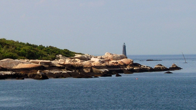
Safely across, I dug the camera out once again and handed it forward for him to take pictures. Minot Light is a 97-foot monolith, impressive up close. We were careful not to approach too close. Jagged rocks hide below the surface, and the waves and tidal currents could easily push us against the unforgiving granite, which could mean disaster in a canvas boat.

The white beacon of Minot Light flashes white once, then four times, then three times, and repeats this pattern every 45 seconds. Local romantics discovered the 1-4-3 sequence to be the same as the letter count in “I love you,” which is why it’s known as the “Lover’s Light.” Today, the light is lit by solar power and continues to warn boats of the hidden hazards and guides large vessels safely in and out of Boston, Hull and harbors to the south.
We rounded the light, passing two anchored fishing boats and headed back toward shore, making for the north end of Egypt Beach, where we were scheduled to meet the rest of our vacation party. But we found ourselves fighting against the tide after rounding the light and instead of heading straight for the shore, we angled to the south a bit, passing a dive boat on the way. A continuous half-hour paddling effort got us near the beach. Ethan kept a sharp lookout for rocks below the surface and cautioned there might be some hidden boulders lurking between two large rockpiles right in our path. The surface wave action revealed no obstructions below, so I convinced him that there was plenty of water to pass and we safely rode the swell toward the shore. After another 20 minutes or so, we negotiated another rock garden and beached the kayak on the smooth sand just a short walk from the North Scituate Post Office.
We were greeted as returning heroes by our family as we stretched legs, backs and arms, happy with our accomplishment. We had finally seen Lover’s Light up close, had viewed our familiar sliver of coastline from a vastly different perspective, and, accomplished our main task of simply messing around in the boat for a while.
MORE KAYAK STORIES:
Escape The Heat By Paddling the Charles River (Great Views of Boston, Too!)
One Night Getaway: A 28-Hour Couples Vacation With Kayaks
Kennebunk Idyll: First Paddle Of The Year
IF YOU GO:
You don’t need to own your own kayak to paddle south of Boston
Kayak rentals:
Kayak and accessory sales:
Home rentals:
Having started kayaking this summer, I certainly enjoyed this.
It is a great sport to take up. The really nice thing is you can enjoy lazy paddles or get as adventurous as you want the more adept you become. Thanks for reading.